Support for new Earth observation instruments is good news for sustainability science.
The most ambitious and comprehensive plans ever for the European space sector, were approved at the end of 2019, with a total budget of €14.5 billion for the European Space Agency for the next three years – a 20% increase over the previous three-year budget. The decision allows a direct uplift to Europe’s Earth observation capability, expanding Copernicus – the European Union’s flagship Earth observation programme – with a suite of new, high-priority satellite missions. In this explainer we delve into the improvements and what they mean for sustainability and climate science.
What is the Copernicus Programme?
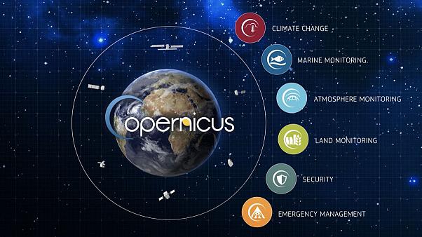
Copernicus is the European Union’s Earth observation programme, coordinated by the European Commission in partnership with the European Space Agency (ESA), EU Member States and other EU Agencies. Established in 2014, it builds on ESA’s Global Monitoring for Environment and Security (GMES) programme. Copernicus encompasses a system of satellites, airborne data, and ground stations supplying global monitoring data and operational services on a free-of-charge basis across six themes: atmosphere, marine, land, climate, emergency response and security.
The Sentinel System – new and improved
At the centre of the programme sits the Copernicus Space Component, which includes a family of satellites known collectively as Sentinels. These spacecraft provide routine atmospheric, oceanic, cryosphere and land global monitoring data, which are made freely available for Copernicus Services and major research and commercial applications such as precision farming, environmental hazards monitoring, weather forecasting and climate resilience.
The soon-to-be-expanded Sentinel system will incorporate six high-priority missions. Set to launch from 2025, each will bring new sensing capabilities.
- Copernicus Anthropogenic CO2 Monitoring (CO2M): This mission will track individual sources of anthropogenic emissions of CO2 with a relatively high spatial-resolution imaging spectrometer;
- Copernicus Land Surface Temperature Monitoring (LSTM): To monitor land surface temperature and rates of evapotranspiration in unprecedented detail via its thermal infrared radiometer;
- Copernicus PolaR Ice and Snow Topography ALtimeter (CRISTAL): To chart sea-ice thickness and snow depth, as well as ice elevation on land equipped with radar instruments;
- Copernicus Imaging Microwave Radiometer (CIMR): A marine-focused mission providing observations of sea-ice concentration, sea-surface temperature and salinity via passive microwave sensing;
- Copernicus Hyperspectral Imaging Mission for the Environment (CHIME): Enhancing services for land-cover mapping, agricultural management and coastal mapping and management, with hyper-spectral imaging;
- Radar Observing System for Europe – L-band (ROSE-L): A mission to support forest management, monitor soil moisture, and discriminate crop types equipped with an L-band radar sensor.
What does this mean for sustainability and climate science?
These new missions will complement the Sentinels and advance our knowledge about large-scale changes to the planet from natural and human activities. Some examples follow.
Improved knowledge of emissions
The inability to monitor atmospheric carbon dioxide resulting from human activity at national and regional scales, is a major knowledge gap that was identified at COP-21 in Paris in 2015, and still remains problematic today. The CO2M mission will help address this issue by providing measurements to reduce current uncertainties in emissions estimates. Moreover, these new data will provide a unique and independent source of information to help assess the effectiveness of climate policy measures, and to track their impact towards decarbonizing Europe and meeting national emission reduction targets.
Monitoring changes in the Arctic
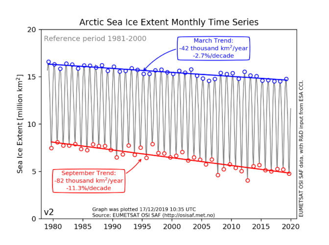
Over the past few decades, global warming has led to widespread shrinking of the cryosphere. As detailed in the 2019 Special Report on the Ocean and Cryosphere we are seeing accelerating warming in the polar and high-mountain regions and reduced mass of ice sheets, ice caps and glaciers, reduced snow cover and Arctic sea ice extent and thickness. With increasingly rapid ocean and polar cryosphere transitions predicted in the near-term, it is critical to adequately monitor these sensitive regions as changes here will extend to the whole planet, with predominantly negative impacts on food security, water resources, ecosystems, livelihoods, health, as well as on the culture of human societies, particularly for Indigenous peoples. Future losses from polar ice sheets remain the largest uncertainty in global climate and sea level projects, whilst their scale and remote, hostile location make satellite measurements the only solution for tracking change. The deployment of CIMR and CRISTAL will ensure continuity of cryospheric observations at this crucial time.
Advancing the UN Sustainable Development Goals (SDGs)
The SDGs provide a framework for global peace and prosperity, encompassing (among other aims) food security, sustainable water management and combating climate change and its impacts. To meet the commitment of achieving these goals by 2030, and to take action, decision-makers need empirical evidence on processes and changes in land and water systems and on their socioeconomic and human health impacts. The LSTM, ROSE-L and CHIME missions will improve our ability to monitor forests, biodiversity, agricultural land, and changes in the water and energy cycles to understand in more detail changes happening in both space and time, in support of the UN SDG goals for more sustainable allocation and use of resources.
In depth: a closer look into each Copernicus Sentinel
CO2M: Copernicus Anthropogenic Carbon Dioxide Monitoring
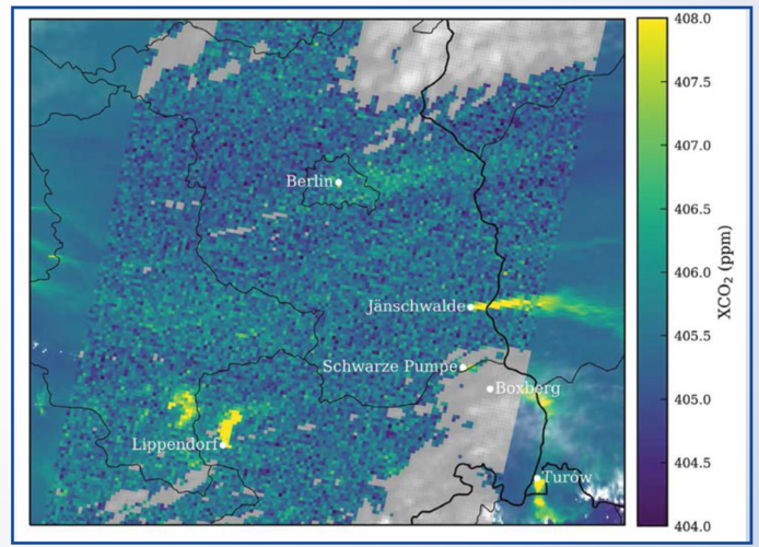
This set of satellites will detect the spectral absorption signals of carbon dioxide in infrared sunlight reflected off Earth’s surface. From this information we will be able to retrieve concentrations of carbon dioxide in the atmosphere with high-precision – to 0.7 ppm (parts per million). The high spatial and temporal resolution planned for this mission represents a step-change in what is currently available for measuring carbon dioxide from space. It will measure carbon dioxide at 2×2 km2 and scan each point of the globe every few days to capture the plumes from individual power plants. The swath – the width of vision – will be more than 250 km per satellite. In addition, the satellites will be given additional instruments that detect nitrogen dioxides emitted from burning fossil fuels at high temperature, which will help locate carbon dioxide plumes produced by humans and distinguish them from carbon dioxide coming from natural sources. The satellites will also have sensors to detect clouds and aerosols to improve carbon dioxide measurement accuracy. Alongside these data, ESA will support a system that provides policy-relevant information based on satellite data and other the development of independent sources of information on carbon dioxide concentrations, including from in-situ networks of sensors.
ESA aims to launch CO2M by the end of 2025, and is expected to provide data from 2026 to support the second global stocktake of greenhouse gas emissions, to be concluded in 2028, by countries participating in the Paris Agreement. The mission is expected to be a potent tool enabling nation states to better understand their carbon footprint, verify national emissions reports using independent data, and to set more ambitious targets. The CO2M mission will also be a valuable source of information for climate modellers, to tune Global Coupled Climate models’ representation of the carbon cycle.
To learn more, read: CO2M Mission Requirements Document
LSTM: Copernicus Land Surface Temperature Monitoring
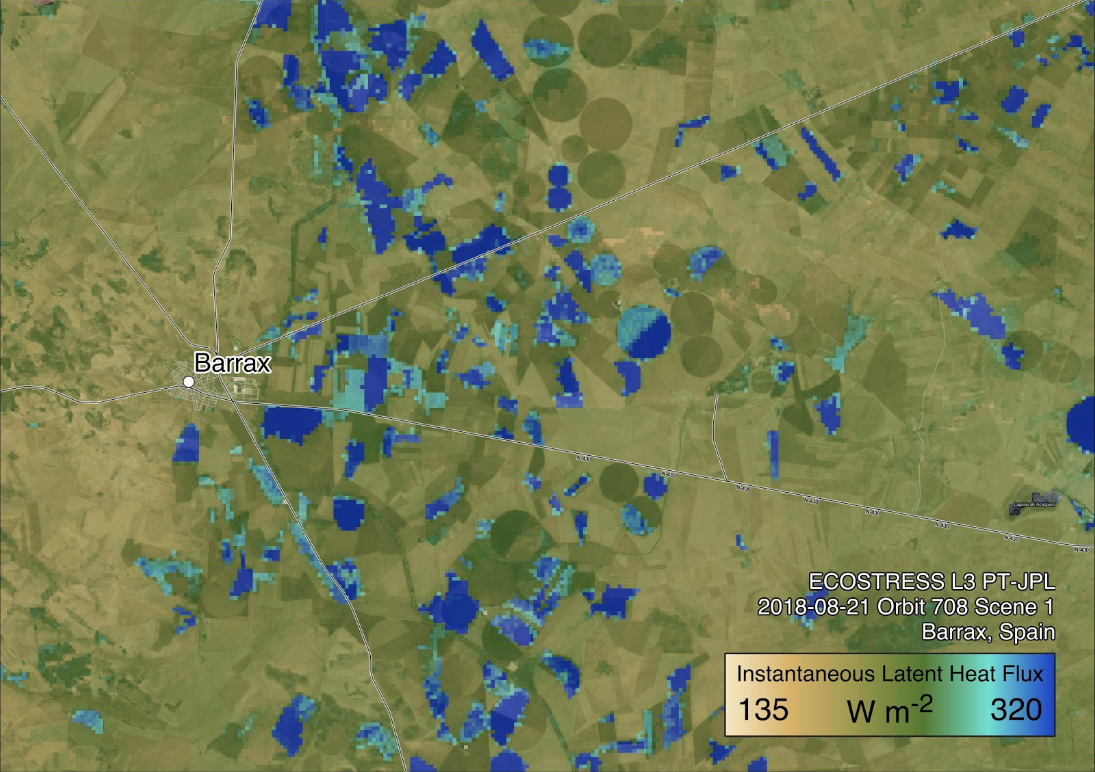
This Copernicus candidate mission will map every 1-3 days the surface temperature of the planet and rates of evapotranspiration – the water vapour emitted by growing plants – at 400 times finer resolution than currently measured from space. It will have a low-Earth polar orbit, with each pixel in its radiometer’s field of view representing a square of size 50 metres. The overpass time will be early afternoon and it will provide daily measurements from five bands in the thermal infrared spectral range 8 ‐ 12.5 μm complemented by bands in the visible and near-infrared. ESA will provide level 2 data (with various corrections and calibrations applied) for land surface temperature, emissivity and bottom of atmosphere surface reflectance per spectral band, total column water vapour and cloud mask information, as well as lower-level products.
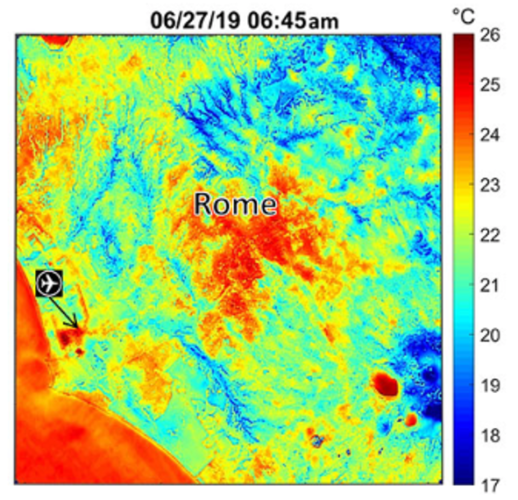
Accurately tracking Earth’s temperature using satellite-derived information helps to explain the physics at the land-surface, including the processes driving energy and moisture exchange with the overlying atmosphere. Monitoring and understanding drought, changes in vegetation, heatwaves, urban heat island effects and the stability and extent of permafrost will all benefit from these data. The mission is focussed on addressing the priority requirements of the agricultural user community for improving sustainable productivity at the field-scale in a world of increasing water scarcity and variability caused by climate change. In particular, the daily evapotranspiration measures provided by LSTM will help farmers to manage irrigation regimes and optimize yield with minimum water supplies. LSTM’s thermal infrared sensing ability will also apply to sea and lake surface temperature monitoring: its high spatial resolution will be particularly useful for tracking small features such as lakes in the Arctic, coastal zones, rivers, coral reefs, ocean upwellings and structures such as oceanic eddies that influence vertical transport of nutrients, crucial for ocean productivity. In an urban context, LSTM will inform planning and ‘climate-adaptive’ building design to deal with heatwaves.
To learn more, read: LSTM Mission Requirements Document
CHIME: Copernicus Hyperspectral Imaging Mission for the Environment
This hyperspectral imaging mission will provide routine observations through the Copernicus Programme for managing natural resources and assets in support of EU policy, and will complement currently flying multi-spectral missions such as Sentinel-2. Compared to multi-spectral missions, CHIME will have an increased number of narrow spectral bands (spectral resolution of 10nm with no gaps between bands) in the visible-to-shortwave infrared range (400-2500nm), which will allow for a more accurate determination of biochemical and biophysical variables.
The mission will provide hyperspectral observations with high radiometric accuracy at a spatial resolution of 20-30m and with a revisit time of 10-12.5 days, using a sun synchronous orbit with overpass time of between 10.30-11.30am. The core products supplied by the mission will be Level-2A atmospheric and geometrically correct surface reflectance, including Bottom-of-Atmosphere (BOA) reflectance, ortho-rectified geometry using a Digital Elevation Model (DEM) and pixel classification (a side product from the atmospheric correction process) allowing users to distinguish opaque clouds, thin clouds, cloud shadows, vegetation, etc. In addition, a set of downstream-products will be proposed to users as part of the mission catalogue to support the operational use of the data.
Products and services from CHIME are expected to support research in the domains of agriculture, food security, raw materials, soils, biodiversity, environmental degradation and hazards, inland and coastal waters, and forestry. The mission will make unique and major contributions towards fulfilling user requirements in the domains of agricultural services and sustainable agricultural management, and raw materials. It will support a number of policies, in particular the UN SDGs (SDGs 2, 12 and 15), the EU Common Agricultural Policy (CAP), the EU Raw Materials Initiative, the UN Convention for Combating Desertification and Land Degradation, the Soil Thematic Strategy and the Soil Framework Directive, the EU Water Framework Directive and the UN Convention on Biodiversity (Aichi Targets).
To learn more, read: CHIME Mission Requirements Document
CRISTAL: Copernicus Polar Ice and Snow Topography Altimeter
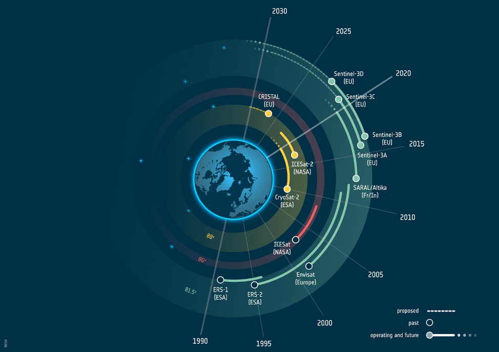
This is a topography mission, aimed at monitoring sea ice thickness, land ice elevation and sea ice thickness and snow load over sea ice in the polar regions at high-resolution. Equipped with a multi-frequency radar altimeter and microwave radiometer, this mission is based on a long heritage of currently flying missions and some in development but not yet launched (e.g. CryoSat-2, SARAL, MetOp-SG, Sentinel-6, Sentinel-3). It responds to the need for continual measurements of the Arctic Ocean and its ice above 81.5 degrees north, and is an improvement over Sentinel-3 (only covers up to 81.5 degrees north). Currently, CryoSat- 2 (an ESA Earth Explorer mission) is the only European satellite providing routine measurements north of 81.5 degrees, and it has been operating in its extended mission scenario for the past three years. CRISTAL’s payload will include a 2-channel SAR radar altimeter (Ku and Ka bands) capable of interferometry to improve on the accuracy of measuring the height of sea ice above the water, called freeboard, and snow depth. A microwave radiometer is included in the payload to support atmospheric corrections and classification of snow and ice types.
Characterising sea ice and ice sheets is important as they are drivers as well as indicators of global climate change. CRISTAL’s high-resolution data will help improve the Essential Climate Variables (ECVs) for glaciers, snow, sea ice and ice sheets and ensure continuity of these important, multi-decadal time series. ECVs are systematic observations of climate required by the UN Framework Convention on Climate Change (UNFCCC) to improve climate models and future projections of global climate change. The altimetry data from CRISTAL will also be useful for retrieving land elevation change in polar regions, for example to monitor slumping due to permafrost thaw, or coastal erosion, as well as inland waters, such as changes in lake height due to draining. The data will provide observations of polar sea level, (sub-)mesoscale currents, wind speed and significant wave height for operational oceanography and marine forecasting services. By delivering a long term record of sea ice thickness, variability and trends, the CRISTAL mission, due to launch 2026/2027, will also support the EU’s commercial interests in the polar regions, for example to support shipping and better climate services. CRISTAL directly addresses the EU Arctic Policy, and the needs of the Copernicus Climate Change Service as well as the Copernicus Marine Environmental Monitoring Service.
To learn more, read: CRISTAL Mission Requirements Document
CIMR: Copernicus Imaging Microwave Radiometer
This multi-frequency microwave radiometer has been designed to provide evidence to support decisions within the European Commission Integrated Policy of the Arctic that has a focus on the Arctic climate emergency. CIMR’s high spatial resolution and high-fidelity measurements will be essential to continue the historical climate record of sea ice concentration derived from microwave radiometry over the past 40 years.
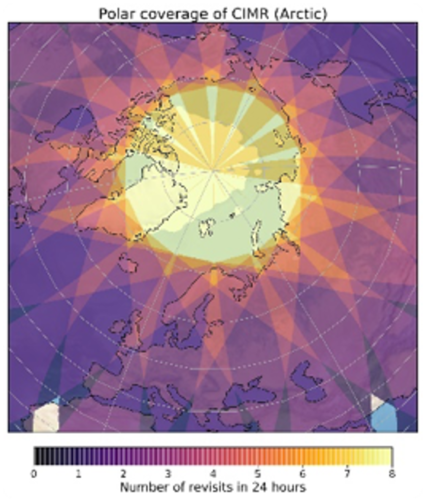
The mission will provide observations roughly every 6 hours the polar regions, focusing on low-frequency channels but uniquely, at high spatial resolution. Observations at microwave frequencies are not affected by clouds – a persistent observational challenge in the Arctic and over the oceans. It will use a dusk-dawn orbit to achieve complete coverage of the Earth’s surface every 2 days using a single satellite. Sea-ice concentration will be derived from dedicated Ku- and Ka-band (18.6 and 36.5 GHz) channels at a resolution of less than 5 km in combination with C-band (6.9 GHz) data.
CIMR’s L-band (1.4 GHz) channel will be useful to determine the thickness of thin – less than 50 cm – sea ice, sea surface salinity and wind speed over the ocean – addressing a data gap at the end of previous ESA and NASA missions. Its C- and X-band (6.9 and 10.65 GHz) channels will support derivations of sea-surface temperature at an unprecedented spatial resolution of 15 km or better, compared to other microwave radiometers. A range of other parameters that could be determined using CIMR include sea ice drift, ice type, snow extent over land, ice surface temperature, snow depth over sea ice and soil moisture. The mission requires a large (~7.5 m) conically scanning antenna in a geometry to provide a wide (greater than 1900 km) swath with ‘no hole at the pole’ coverage to meet user needs. It will fly in synergy with the MetOp-SG (A1 and B1) satellites to take full advantage of complementary scatterometer and microwave radiometer data – notably for surface winds where CIMR and MetOp SG-B1 measurements are phased such that they provide near seamless coverage of the ocean every day.
CIMR will also contribute significantly to monitor climate change across a number of essential climate variables, including sea surface temperature, sea ice concentration, land surface temperature, sea surface salinity, sea state, snow extent, soil water equivalent, permafrost, lakes, ice-sheets and soil moisture. The data will be useful for all the Copernicus services, including sea ice services for ship navigation, land, weather and climate.
To learn more, read: CIMR Mission Requirements Document
ROSE-L: L-band Synthetic Aperture Radar (SAR)
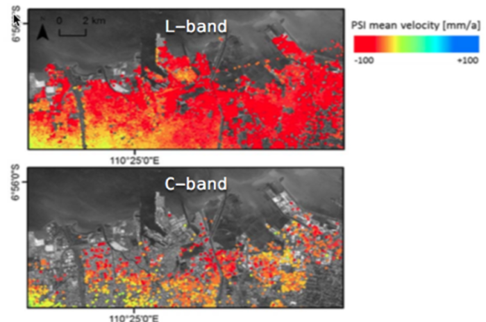
This L-band SAR mission will provide new information that complements and addresses gaps in existing satellite missions such as Sentinel-1. For instance, ROSE-L’s long wavelength will be able to measure surface deformation in vegetated areas currently inaccessible to missions operating with a shorter wavelength. This will greatly extend the earthquake zones and regions at risk of landslides that can be systematically monitored from space. Information from ROSE-L will also improve the accuracy of measurements of forest biomass and changes in forest cover and condition across the globe.
Other applications that benefit from the unique capabilities of ROSE-L include the mapping of soil moisture at field scale throughout the vegetation season, which will support improved agricultural crop monitoring and water use, as well as better land cover mapping. Over oceans ROSE-L will be used to monitor wave direction and wave heights, support improved vessel detection for civil security applications and pollution control. Maritime safety and security applications will benefit from its AIS capabilities. In polar regions data from ROSE-L will be put together with Sentinel-1 to improve sea ice mapping and provide new information on shipping obstacles such as ice ridges and deformed sea ice.
ROSE-L is currently expected to achieve complete coverage of Earth’s surface every six days based on two satellites. Over Europe ROSE-L is expected to image all of Europe in 3 days or less and once per day in the Arctic. The spatial resolution is expected to be better than 50 m2, or roughly 2x better than the current Sentinel-1 IWS product. ROSE-L is expected to operate in the same orbit as Sentinel-1 providing frequent and complementary SAR coverage of Europe and the world.
To learn more read: ROSE-L Mission Requirements Document
Key Contacts
Sophie Hebden
Research Coordinator – Earth observations
Future Earth liaison seconded to ESA Climate Office
Science Reviewers
Mark Drinkwater
Head, Earth and Mission Science Division, ESA
Hannah Liddy
AIMES Executive Officer
Center for Climate Systems Research, Columbia University
NASA Goddard Institute for Space Studies
Yasjka Meijer
CO2M Mission Scientist
Earth and Mission Science Division, ESA
Benjamin Koetz
LSTM Mission Scientist
Exploitation & Services Division, ESA
Michael Rast
CHIME Mission Scientist
Senior Advisor Earth Observation Programmes, ESA
Craig Donlon
CIMR Mission Scientist
Earth and Mission Science Division, ESA
Michael Kern
CRISTAL Mission Scientist
Science, Applications and Climate Department, ESA
Malcolm Davidson
ROSE-L Mission Scientist
Earth & Mission Science Division, ESA
